
Active tectonics
Crustal earthquakes and the seismic cycle
I am interested in the use of InSAR to study active crustal deformation produced by both tectonic and volcano-tectonic processes. Geodetic data can provides critical information not available by point source seismic inversions like the complexity of fault slip in the Earth’s surface, evidence for complex rupture geometries and the role of magmatic fluids in aseismic deformation. InSAR also provides insights on large scale mechanisms of deformation across orogens.

TerraSAR-X wrapped (a) and unwrapped (b) interferogram of the July 17 2013 Mw 5.9 earthquake in the Mojopampa normal fault NW of Sabancaya volcano (black triangle) in Southern Peru. The geodetic focal mechanism is in agreement with the seismic moment tensor, showing that there is no evidence for fluid-driven deformation (Jay, Delgado et al., 2015). Wrapped (c) and unwrapped (d) TerraSAR-X mean velocity calculated from InSAR time series from November 2013 to December 2016 showing ~4-5 cm of uplift produced by a deep inflating source beneath Hualca Hualca volcano. The inflation likely triggers aseismic afterslip in the Mojopampa fault, which is better observed in the wrapped interferogram (Macqueen, Delgado et al., 2020).
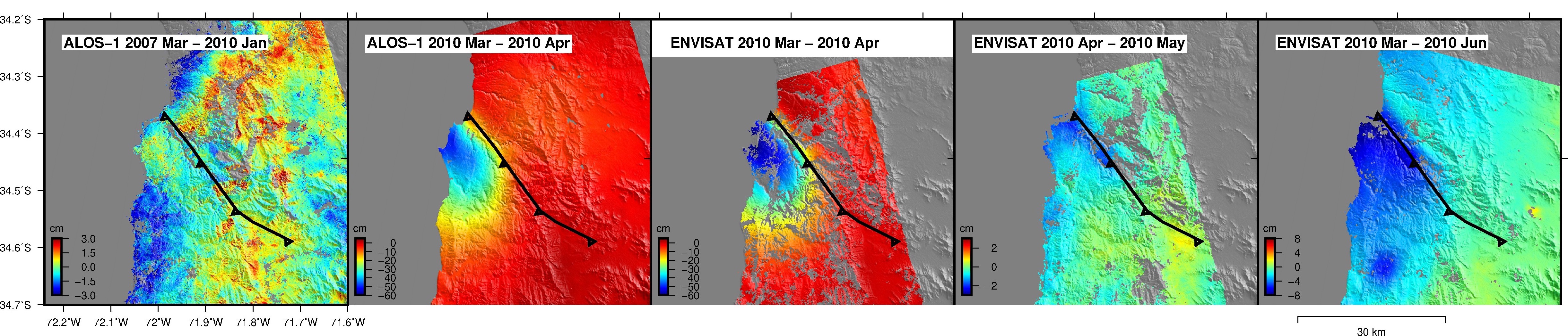
Interferograms that span the seismic cyle of the Pichilemu fault (black lines) in Central Chile. This fault ruptured in two Mw 7.0 eqarthquakes triggered by the Mw 8.8 Maule megathrust earthquake in 2010. Thr first interferogram shows no interseismic strain accumulation three years before the earthquake, the second and third interferograms show the coseismic rupture imaged by L-band ALOS and C-band ENVISAT data, and the last two interferograms show stress-driven afterslip triggered by the coseismic rupture during a time span of 3 months.
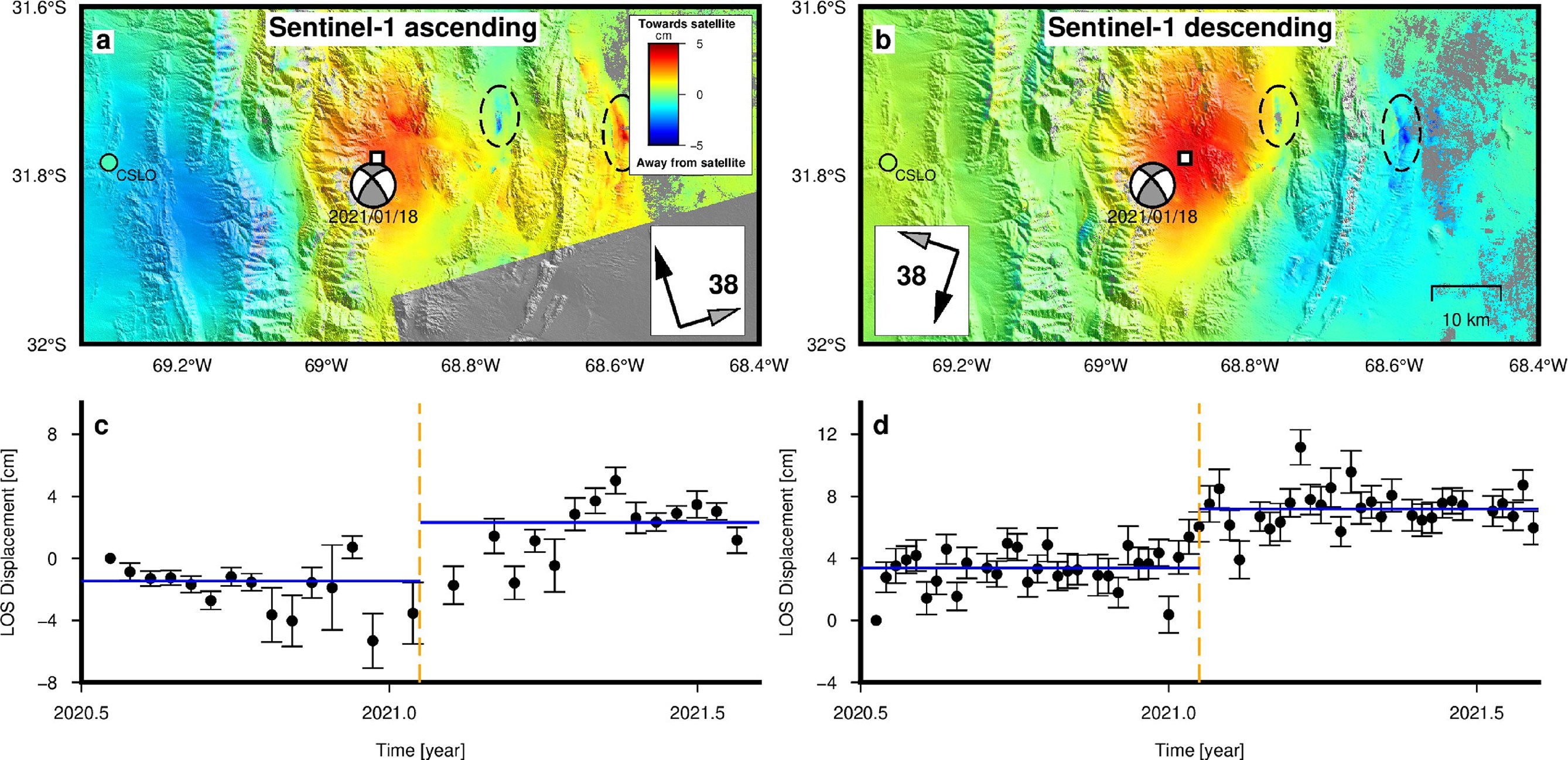
Reconstructed line-of-sight (LOS) ground displacement for ascending and descending tracks (a and b, respectively). White squares indicate the locations of maximum displacement, while dashed elipses highlight deformation unrelated to the main dislocation. Coloured circles represent the solution of CSLO GNSS station reported by Ammirati et al. (2022) projected to the respective LOS. Focal mechanism is also from Ammirati et al. (2022). Panels (c) and (d) show the Heaviside-like function fit to the maximum displacement data, with vertical dashed line representing the prescribed step at the earthquake date (León-Ibáñez and Delgado, 2025).
Strike slip faults
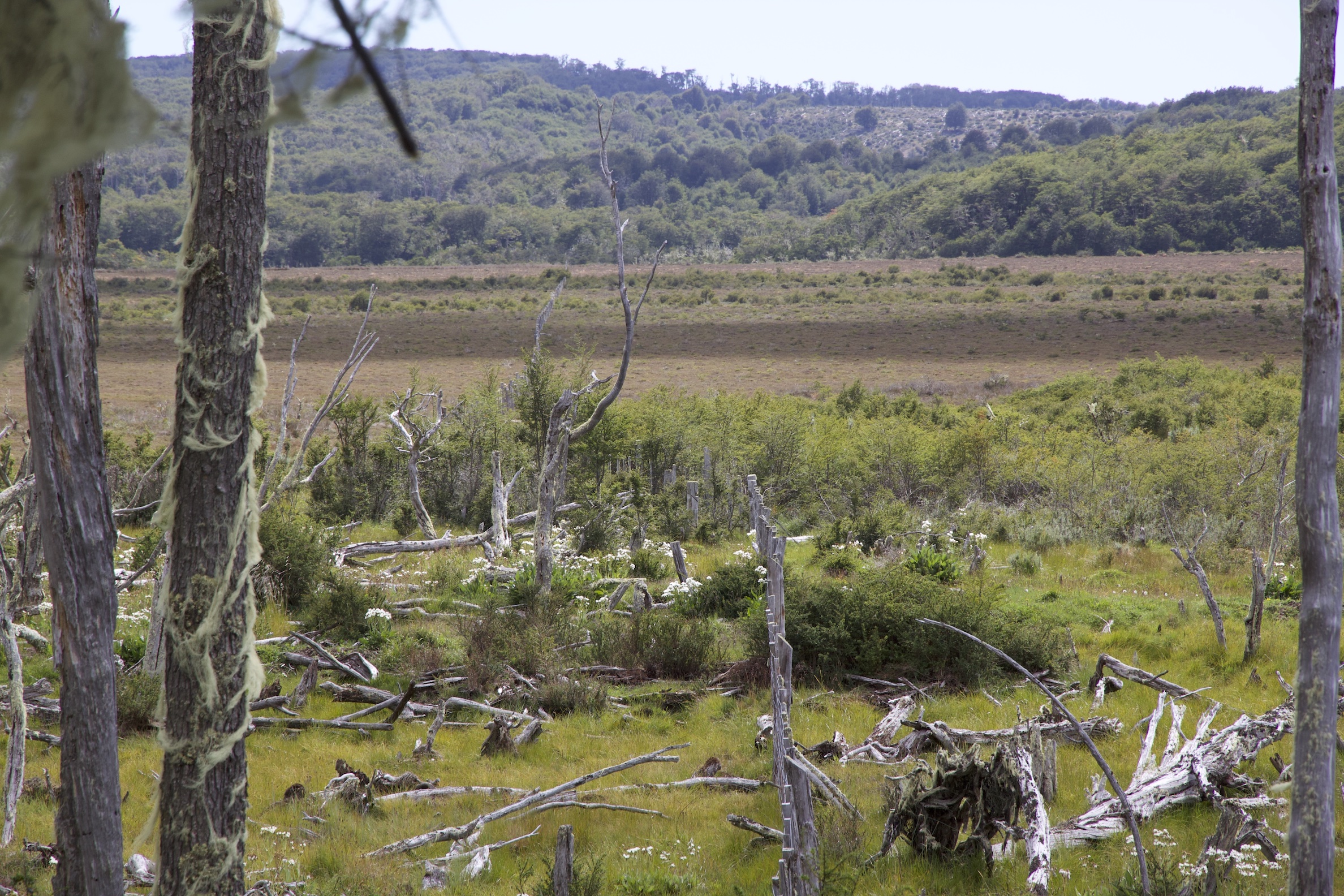 Fence displaced ~6 m by the 1949 Mw ~7.2 sinistral doublet in the Magallanes Fagnano fault, Tierra del Fuego.
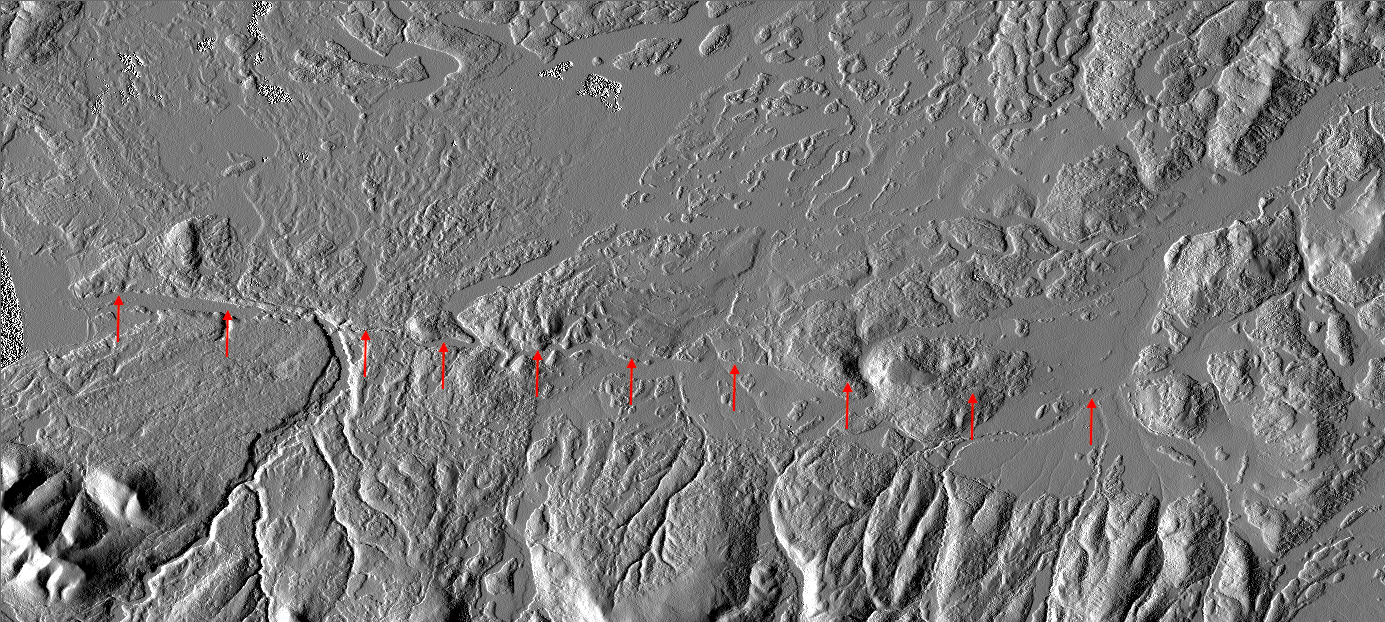 12 m shaded relief TanDEM-X DEM of spanning the Magallanes Fagnano fault. The red arrows show a ~25 km long segment of the 1949 rupture.
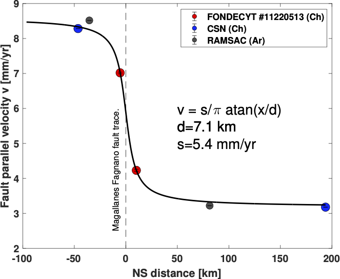
Fault parallel velocities from continuous GNSS as a function of the distance from the trace of the left lateral strike-slip Magallanes Fagnano. The black line is the synthetic velocity predicted by the best-fit infinitely long vertical screw dislocation model.
Relevant publications
Interseismic strain accumulation along the Chilean segment of the Magallanes - Fagnano fault zone recorded by continuous GNSS.
Delgado, F., Baez, J. C., León-Ibáñez, P., 2025. Journal of South American Earth Sciences, doi:10.1016/j.jsames.2025.105889.
Resolving ground deformation of a blind mid-crustal earthquake with InSAR amid strong phase delays: a case study of the 2021 Mw 6.4 San Juan earthquake and implications for a non-optimal fault reactivation (Andean Fold and Thrust Belt, Argentina).
León-Ibañez, P., Delgado, F., 2025. Geophysical Journal International, 243, 3, ggaf394, doi:10.1093/gji/ggaf394
A global assessment of SAOCOM-1 L-band stripmap data for InSAR characterization of volcanic, tectonic, cryospheric, and anthropogenic deformation.
Delgado, F., Shreve, T., Borgstrom, S., León-Ibañez, P., Castillo, J., Poland, M.,2024 IEEE Transactions on Geoscience and Remote Sensing, doi:10.1109/TGRS.2024.3423792.
Fully joint inversion of the 2016 Mw 7.6 Chiloé earthquake.
Bravo, F., Peyrat, S., Delgado, F., Fuentes, M., Derode, B., Pérez, A., Campos, J., Geophysical Journal International, 2023, 232, 3, 2001–2016, doi:10.1093/gji/ggac411
Volcano-tectonic interactions at Sabancaya volcano, Peru: eruptions, magmatic inflation, moderate earthquakes, and fault creep
MacQueen, P., Delgado, F., Reath, K., Pritchard, M., Lundgren, P., Milillo, P., Bagnardi, M., Macedo, O., Aguilar, V., Lazarte, I., Machacca, R., Miranda, R. Journal of Geophysical Research. 2020, doi.org/10.1029/2019JB019281. Special issue on Creep on continental faults and subduction zones: Geophysics, geology, and mechanics.
Deformation and seismicity near Sabancaya volcano, southern Peru, from 2002 to 2015
Jay, J.A., Delgado, F.J., Torres, J.L., Pritchard, M.E., Macedo, O., Aguilar , V. Geophys. Res. Lett.. 2015, 42, 2780–2788. doi: 10.1002/2015GL063589.